A proven platform, large-scale data, and measurable results

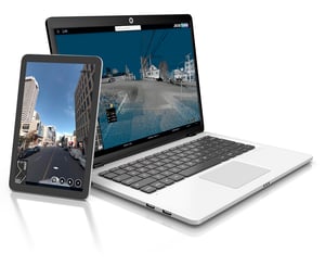
Jakartowns
Navigate, measure, and share large-scale LiDAR and 360° imagery
Jakartowns, as if you were there!
Turn your LiDAR and 360° imagery into actionable insights: virtual inspections, accurate measurements, and asset inventories that speed up operations and reduce field time.
Powerful yet easy-to-use tools for managing and delivering LiDAR data
Engineering grade digital twin, allow users to reduce drastically field time!
Conduct asset inventory in the digital twin environment and seamlessly export data to your GIS.
Key features
- Cloud hosting for massive datasets: Centralize LiDAR and imagery in a secure environment designed for large volumes.
- Fast web delivery: Stream data to clients and partners with links, web services, and integrations—no bulky file transfers.
- Interactive 3D viewer: Explore point clouds and 360° imagery, validate capture quality, and support client reviews.
- Built for production workflows: Import/export geospatial data, manage projects, and deliver GIS-ready outputs.
Plugins, APIs & Interoperability
Jakartowns is built to integrate seamlessly with your existing GIS and enterprise systems—so your 360° imagery and LiDAR data can flow directly into operational, reporting, and asset management workflows.
- GIS-ready integrations: Custom APIs and plugins that support ESRI, JMAP and QGIS workflows.
- Enterprise connectivity: Connect with city systems, asset management platforms, and data services to support downstream processes.
- System-agnostic by design: Integrate Jakartowns with third-party platforms, including GIS, asset management, and enterprise tools.
Jakarto is an Esri Partner with extensive experience integrating 360° imagery and LiDAR data into established municipal GIS environments.

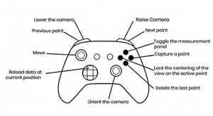
Gamification-ready
Navigate digital twin as if you were in a video game.
Jakartowns supports game controllers (PlayStation® and Xbox® style) in free-navigation mode, delivering a smoother, more immersive user experience.
Explore cities, inspect power line, and move through LiDAR and 360° imagery naturally and intuitively—making reviews, demos, and collaborative sessions faster, more engaging, and easier for everyone.
Trusted by leading organizations
Municipalities and organizations that rely on trusted data to better manage their infrastructure