A proven platform, large-scale data, and measurable results

Applications
Digital twin solutions and precise asset inventories designed for a wide range of applications.
Digital Twins & Asset Inventories
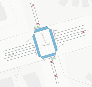
Build an engineering-grade digital twin of your territory and generate accurate asset inventories, faster and with less fieldwork.
Access precise locations and measurements to plan interventions, optimize resources, and prioritize operations with confidence.
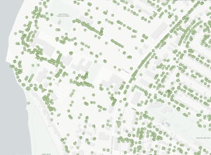
Urban Forestry
Build an accurate inventory of trees and urban canopy using an engineering-grade digital twin.
Map each tree precisely, assess canopy cover and density, and capture key attributes such as height, crown spread, and diameter at breast height (DBH).
Track changes over time to plan maintenance, target planting efforts, and support sustainable, data-driven urban forest management.

Environment & Ecotax
Enhance urban forest management with precise, up-to-date data.
Contribute to reducing heat islands, improving air quality, and preserving biodiversity.
Facilitate the implementation of ecotax programs related to vegetation cover and generate revenue.
With annual updates, make informed decisions to support a sustainable urban environment.
Contribute to reducing heat islands, improving air quality, and preserving biodiversity.
Facilitate the implementation of ecotax programs related to vegetation cover and generate revenue.
With annual updates, make informed decisions to support a sustainable urban environment.
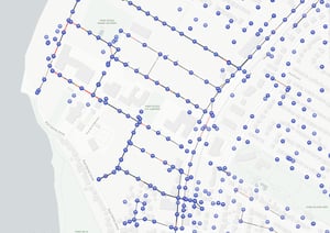
Overhead Network
Optimize network management with digital twins and asset inventories.
Map vegetation encroachments and detect changes such as clearance and asset tilt.
Our solutions reduce field visits, streamline interventions, and boost productivity.
Map vegetation encroachments and detect changes such as clearance and asset tilt.
Our solutions reduce field visits, streamline interventions, and boost productivity.

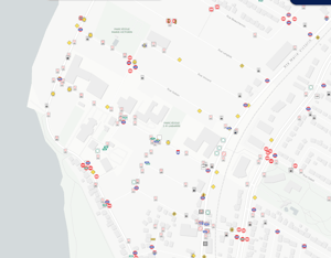
AI-Driven asset inventory
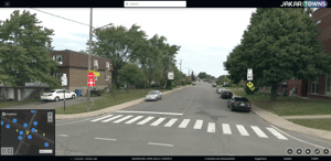
Our advanced AI algorithms enable automated detection of all street-visible assets directly from our 3D data and 360° imagery.
Comprehensive inventories that transform data into a clear, precise, and detailed reality.
Trusted by leading organizations
Municipalities and organizations that rely on trusted data to better manage their infrastructure