ROAD INTERSECTIONS
Road Intersections
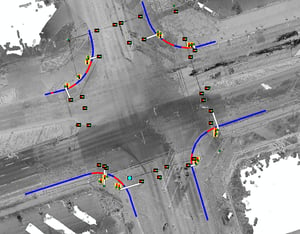
This inventory data is generated from the existing Jakarto HD LiDAR data available in the Jakartowns web application. See our coverage map.The inventory data at intersections are available in one deliverable and one bonus:
- 2D Data: Data file (.shp), File Geodatabase (.gdb), or Geopackage (.gpkg) containing the geolocation of items and some attributes;
- Bonus - Jakartowns context URL: For each element, a hyperlink is associated and can be activated to open Jakartowns directly at the location of the element to visualize the entire geographical context.
Inventory Technical Details
2D Polygonal Element
- Site defining the intersection, namely the location where the survey of point and linear elements is conducted.
3D Point Elements
- Traffic light controller
- Road sign head
- Bicycle sign head
- Pedestrian sign head
- Solar panel
- LED panel
- Flashing beacon
- Camera
- Aerial detection equipment
- Pole
2D Linear Elements
- Road traffic signal arm
- Bicycle signal arm
- Pedestrian signal arm
- Pedestrian crossing signage
- Road signal cable
Key information
GEOGRAPHIC COVERAGE
In the event that your geography is not yet in the Jakarto catalog, and according to our geographic coverage planning, the data you desire could be produced as a priority. In the case of a geography outside our planning, they could be produced on request and after evaluation.
QUALITY AND COMPLETENESS
Although every effort is made to ensure the completeness of the inventory data, it is possible that the inventories may not be 100% complete. If an object obstructs the view of the capture unit, an item behind it cannot be recorded. Therefore, items might be missing in the delivered inventories; we try to limit the proportion of such occurrences.
Jakarto in numbers
150
CITIES ALREADY DIGITIZED
100 000+
KILOMETERS DIGITIZED