Urban Forestry management
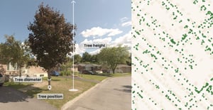
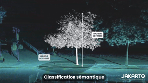
Tree Inventory
Each detected tree is delivered with operationally useful attributes:
- Unique tree ID and location
- Tree height
- Trunk diameter (DBH)
- Trunk ID
- Height of the lowest branch
- Projected crown area
- Reference to the associated canopy polygon
- Link to view in Jakartowns
- Scan date
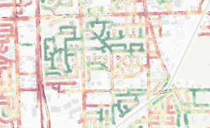
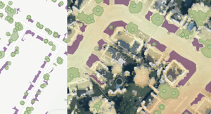
Urban Canopy
Ideal for quantifying canopy cover and supporting greening targets:
- Unique canopy ID
- Ground projection (footprint)
- Maximum canopy height
- Area (m²)
- Wooded-area indicator
- Jakartowns link
Planting Sites
Identify the best tree planting locations by considering the surrounding environment: soil type, proximity to overhead networks, buildings, and existing vegetation.
We help you maximize planting success while reducing the time and effort spent on field surveys to find suitable sites.
Inventory from Aerial Data
Extend coverage beyond the street.
In addition to mobile LiDAR, Jakarto now offers tree inventories from aerial LiDAR data.
Ideal for covering large areas (parks, back lots, woodlands, less accessible zones) and accelerating territory-wide understanding.

Advanced Vegetation Analysis
Go beyond inventory and get concrete indicators to prioritize actions and track changes in vegetation over time.
- Local canopy index
- Airspace congestion index
- Vegetation clearance height
- Vegetation encroachment on assets
Eco-Taxation Program
Make it easier to implement ecofiscality programs tied to vegetation cover.
Jakarto’s analyses help identify properties that are compliant—or not—with local regulations.
With annual updates, track vegetation cover over time and generate revenue while supporting urban sustainability.
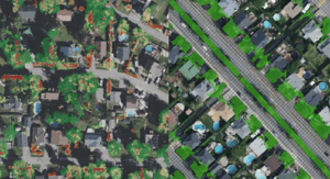
Pervious & Impervious Surface Identification
To better plan planting and support your greening goals, Jakarto identifies pervious and impervious surfaces using digital twin data.
- Clear polygon-based classification
- Decision support for planting
- An essential complement to planting-site identification
- Visualization of capture areas and water retention zones


Trusted by leading organizations