Skip to content
Close
Applications
Digital Twins & Asset Inventories
Urban Forestry; Tree and Canopy
Eco-Taxation Program
Overhead Network; Telco & Energy
Geo Intelligence
Industries
City & Government
Public Utilities
Engineering & Surveying
Ports & Airports
Solutions
Reality Capture
Asset Inventories
Road Signs
Vegetation
Overhead Network
Catch Basins, Manholes, Water Valves
Fire Hydrants
Road Pavement Condition
Pavement Markings
Streetlight
Intersections
Platform
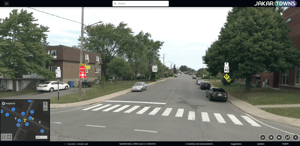
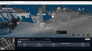
3D - Jakartowns
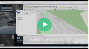
2D - Assets viewer
Ortho - Tiles
PlugIns
API
About us
Contact us
The Team
Videos
News
Be Partners
SEARCH
LANGUAGE – en
fr
Log in
Access the platform
Applications
Digital Twins & Asset Inventories
Urban Forestry; Tree and Canopy
Eco-Taxation Program
Overhead Network; Telco & Energy
Geo Intelligence
Industries
City & Government
Public Utilities
Engineering & Surveying
Ports & Airports
Solutions
Reality Capture
Asset Inventories
Road Signs
Vegetation
Overhead Network
Catch Basins, Manholes, Water Valves
Fire Hydrants
Road Pavement Condition
Pavement Markings
Streetlight
Intersections
Platform
3D - Jakartowns
2D - Assets viewer
Ortho - Tiles
PlugIns
API
About us
Contact us
The Team
Videos
News
Be Partners
en
fr
Log in
Access the platform
Search Suggestions
Vidéos
Presentation of Jakarto
Quick overview of products and services
Félix Laroche, President, explains the vision behind Jakarto
The absolute inventory potential of Jakarto's digital twins
Jakartowns Tutorials
How to move around Jakartowns
How to create your Jakartowns account
How to create a 3D inventory and export it to your GIS
Presentation of Jakartowns measurement tools
Evaluate Jakartowns for yourself by activating your free trial