We map at traffic speed (15 to 90 km/h) and deliver a digital twin within 72 hours of data upload.
Reality Capture
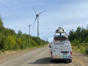
Our mapping units capture HD LiDAR & 360 Imagery
Mobile mapping
Our units combine high-precision LiDAR and 360° cameras to capture reality and quickly map large territories and their infrastructure.
This safe, unobtrusive data collection enables the creation of a digital twin of the city/territory.
Data is processed and available online within 48 hours of being uploaded to our cloud...
.

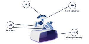
Multi-sensors data acquisition unit
Jakarto’s mobile mapping units combine high-precision LiDAR and Ladybug6 360° cameras (72 MP) to capture roadway-visible assets and measurements—powering an actionable digital twin of the territory.
- Up to 2,000,000 measurements per second
- 25,000 km/year capture capacity
- Down to 5 cm GIS accuracy (90% of measurements)
- Year-round operations
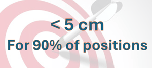
Our accuracy
Our data delivers sub-5 cm positional accuracy for asset locations in 90% of cases.
With regularly calibrated equipment and rigorous quality control at every step, we ensure the reliability of your digital twin and the asset inventories derived from it.
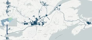
Our coverage
We have mapped over 150,000 km of LiDAR and 360° imagery across Eastern Canada, covering more than 150 cities — positioning Jakarto as a Canadian leader in the field.
This high-quality data is available directly in our platform, providing a complete, consistent, and up-to-date view of the territory.
Versatility
Our mobile mapping units capture the data needed to build digital twins, generate asset inventories, and perform precise measurements—distances, areas, heights, clearances, and offsets between assets.
Simplicity
They operate freely, with no road closures, enabling fast and safe surveys without disrupting traffic.
.png?width=300&name=Light%20(2).png)
Precision
We deliver engineering-grade geospatial data that meets the highest requirements for digital twin creation and AI-driven asset extraction.

Speed
Trusted by leading organizations
Municipalities and organizations that rely on trusted data to better manage their infrastructure