
Once again this year, Jakarto will be attending Geo Week in Denver, one of the must-attend events for the geospatial industry in North America.
This event is the perfect opportunity to connect with the community, discuss market challenges, and demonstrate how LiDAR data and 360° imagery can be fully leveraged through a cloud-based platform designed for real-world operations.
📊 What to expect at Geo Week 2026
Geo Week 2026 is shaping up to be a major edition, featuring:
-
225 exhibitors
-
3,500 attendees
-
50 conference sessions
An ideal setting to explore the latest innovations, connect with industry leaders, and build the collaborations of tomorrow.
💻 Live demonstrations of the Jakarto platform
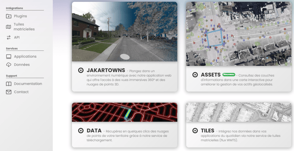
At Geo Week, our team will showcase the Jakarto platform, a cloud-based solution designed for the storage, processing, visualization, and large-scale distribution of LiDAR and 360° imagery data.
Visitors will discover how to:
-
Centralize and structure large volumes of geospatial data;
-
Visualize a rich, measurable digital twin directly in a web browser;
-
Extract asset inventories and high-precision measurements from field data;
-
Deliver interoperable data ready to integrate into GIS and existing systems.
Our goal is simple: reduce the friction between data collection and real operational use.
🤝 A strengthened presence with nfoldROI
This year, we are proud to be joined by nfoldROI, our partner and reseller of the Jakarto platform for the U.S. municipal market.
This strategic partnership enables us to offer U.S. cities a proven solution that combines:
-
The technological power of the Jakarto platform;
-
nfoldROI’s field expertise and deep understanding of the municipal market;
-
A use-case-driven approach covering asset management, infrastructure, urban forestry, planning, and operations.
Together, we support municipalities in their digital transformation by providing accurate, measurable, and evolving knowledge of their territory.
🌍 Geo Week: a place to shape the future
Geo Week is more than a trade show—it’s a collaborative space where data producers, integrators, technology providers, and end users come together. For Jakarto, it’s an opportunity to:
-
Present the latest platform enhancements;
-
Discuss GIS integration and interoperability;
-
Explore new collaborations across the North American market.
🙏 Thank you to the event partners
We would like to thank the key partners of Geo Week who contribute to the reach and quality of this major geospatial industry event:
-
ASPRS (American Society for Photogrammetry and Remote Sensing), a global reference in photogrammetry, remote sensing, and geospatial sciences;
-
Reality Capture Network, a leading community dedicated to reality capture technologies and their real-world applications;
-
Diversified Communications (DIVCOM), organizer of Geo Week, recognized for its pivotal role in connecting the global geospatial ecosystem.
Their commitment helps bring the community together and collectively advance geospatial innovation.
Will you be at Geo Week?
Come meet us to discuss your challenges, see the Jakarto platform in action, and learn more about our collaboration with nfoldROI.
📆 February 16–18, 2026 📍 Booth 729 🌐 Colorado Convention Center, Denver
See you on the Geo Week show floor!
COMMENTS