A proven platform, large-scale data, and measurable results
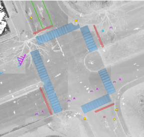
ASSET INVENTORIES
Extracted from digital twin
AI-DRIVEN ASSET INVENTORY
Automatically extract assets from an engineering-grade digital twin captured with engineering-level accuracy by Jakarto’s mobile mapping units or our partners.
IN THE SPOTLIGHT - JAKARTO ASSET INVENTORY
Traffic Signal Maintenance: Toronto Relies on Jakarto Data and the Esri Ecosystem
Following the Esri Canada User Conference in Toronto, numerous discussions helped highlight the full potential of Jakarto’s ...
Start Reading
Jakarto’s Intelligent Pavement Analysis
🛣️ From Crack Detection to Freeze–Thaw Monitoring. Road surfaces are at the heart of our transportation infrastructure, and ...
Start Reading
Tree Inventory and Inspection Cycle: The Foundation of Sustainable Urban Forest Management
🌳 Tree Inventory and Inspection Cycle: The Foundation of Sustainable Urban Forest Management The effective management of an ...
Start Reading
The Jakarto Advantage : by the Numbers
150 000+
km covered
+150
Cities mapped
3 200 000 +
Geocoded assets
2,500+
tb hosted
Trusted by leading organizations
Municipalities and organizations that rely on trusted data to better manage their infrastructure


Do you need asset inventories?
Discover how AI can accelerate your operations.
Outils et Services
Filter by:
NEW
Web Application
Platform
A true toolbox for professionals in mapping, urban planning, and spatial data analysis
Web Application
Jakartowns
Software for the visualization and exploitation of 3D data from Jakartowns
NEW
Web Application
Tiles
Utilize Jakarto's point clouds in the form of 2D data layers
NEW
Web Application
Data
Explore Jakarto's point clouds with Data, for effortless downloading and integration.
NEW
Web Application
Plugins
Directly accessing the detailed visual environment of your objects of interest in Jakartowns, from QGIS, ArcGIS Pro, or JMap.
