Jakarto is introducing a turnkey, on-demand mobile mapping service designed for engineering, surveying, and construction firms, as well as consultants delivering projects that require precise geospatial data from mobile mapping.
No need to invest in expensive equipment — Jakarto provides everything you need, when you need it.
🎯 Mobile mapping made accessible — with no compromise
💸 Avoid equipment costs: purchasing or renting a mobile mapping system can be expensive
📑 Easily respond to RFPs: MTQ, Hydro-Québec, municipalities... be ready without the hassle
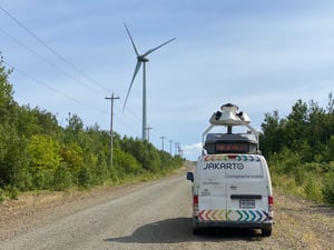
🚐 Access our mobile mapping units: three Jakarto vehicles available by the day or half-day, operated by our team
🧰 What’s included in the turnkey service
🛣️ High-density LiDAR data — By intensity or colorized.
📸 High-resolution 360° imagery — captured every 5 meters.
📡 High-precision geospatial positioning — GNSS + RTK + inertial system.
⏱️ Fast delivery — your data ready within 72 hours of acquisition.
🧠 Automated extraction of unvalidated assets powered by AI:
🔧 Manholes and catch basins
🚒 Fire hydrants
🚧 Road signage
🌳 Trees, crowns, and canopy
🖥️ Visualize and work with your data online
All deliverables are compatible with Jakartowns (immersive 3D view) and Asset Viewer (interactive 2D map), with no software installation required.
📁 Provided formats: .las .webp GeoPackage in NAD83 (CSRS) / MTM
🤝 A reliable solution for confident bidding
💼 No need for your own equipment or technical personnel
📈 Gain agility and stay competitive
📝 Submit strong proposals with professional-grade deliverables
📩 Ready to map without the constraints?
Contact our team to book a unit or request a custom quote. 📧 Contact us
COMMENTS