🛣️ From Crack Detection to Freeze–Thaw Monitoring.
Road surfaces are at the heart of our transportation infrastructure, and their maintenance remains a constant challenge. Thanks to high-precision LiDAR scanning (2 million measurements per second) and Jakarto’s AI algorithms, it is now possible to gain a complete, detailed understanding of pavement conditions — from fine crack detection to the analysis of freeze–thaw impacts.
Jakarto offers a multi-scale approach that goes far beyond traditional inspections:
-
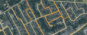
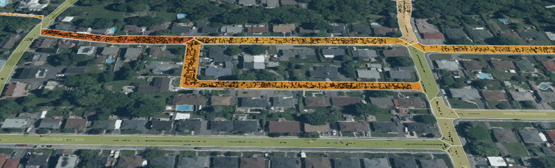
Crack detection: measurement of length, depth, orientation, and distribution.
-
Hexagonal analysis: classification of pavement quality by homogeneous segments.
-
Management indices: surface roughness, transverse and longitudinal cracking, and an overall quality index.
All this information is delivered in GIS-compatible formats and seamlessly integrated into Jakartowns and the Asset Viewer, giving infrastructure managers an intuitive interface to visualize, compare, and prioritize maintenance activities.
⏱️ Annual Monitoring Instead of Every Five Years
Traditionally, pavement inspections are carried out on a five-year cycle — often forcing municipalities to react to issues rather than prevent them. With Jakarto, cities can now be mapped every year, providing:
-
Continuous and rigorous monitoring of pavement evolution.
-
Early detection of degradation before it becomes critical.
-
More proactive and cost-effective maintenance planning.
This shift in approach transforms road management into a dynamic and preventive process, rather than a series of isolated interventions.
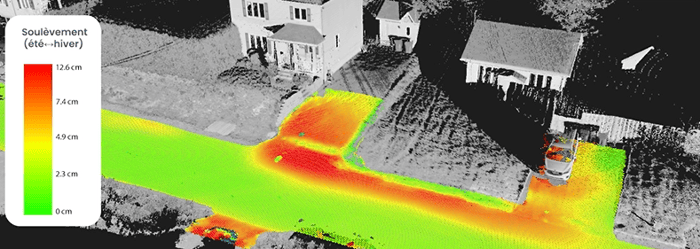
❄️ Adding a New Dimension: Freeze and Thaw
In Québec, freeze–thaw cycles are a major factor in pavement deterioration. In collaboration with the City of Québec, Jakarto demonstrated the effectiveness of 3D surveys in identifying seasonal heaving and measuring its extent.
-
Thermal maps reveal the most vulnerable areas (pages 6–8, 13–17 of the report).
-
City managers can anticipate at-risk zones, plan budgets, and reduce emergency repair costs.
This ability to combine structural analysis with climate impact assessment positions Jakarto as a key player in proactive road management.
💡 A Decision-Making Tool
By combining crack analysis, road marking inventory, and freeze–thaw monitoring, Jakarto empowers municipalities to:
-
Objectively prioritize maintenance work.
-
Optimize budgets with a clear understanding of actual needs.
-
Maintain a historical record within the digital twin for long-term planning.
-
End the traditional five-year inspection cycle: by mapping the city annually, Jakarto enables consistent, reliable monitoring of pavement conditions.
👉 Jakarto enables consistent and rigorous monitoring of pavement conditions.
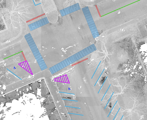
🎨 And What About Road Markings?
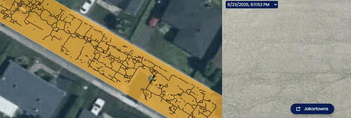
Beyond pavement condition, Jakarto also provides a comprehensive inventory of road markings — whether point features (directional arrows, symbols), linear markings (continuous or dashed lines, bike lanes), or polygonal elements (crosswalks, stop lines).
-
Each marking is identified by its type, position, color, and description.
-
The inventory is based on standardized datasets, including Québec’s Tome V – Road Signage reference.
-
This data allows cities to plan road marking maintenance efficiently, ensure user safety, and maintain network visibility over time.
🌟 Conclusion
By combining pavement analysis with freeze–thaw monitoring, Jakarto delivers a unique and innovative solution.
This approach — powered by the precision of Z+F LiDAR, AI-driven automation, and real-world collaborations like the City of Québec — transforms how municipalities manage their roads.
Above all, it enables annual monitoring of pavement evolution, enhancing road safety and reducing maintenance costs — with far greater precision and relevance than traditional five-year inspections.
COMMENTS