
Following the Esri Canada User Conference in Toronto, numerous discussions helped highlight the full potential of Jakarto’s digital twins for major Canadian cities already mapped and available through Jakarto — Toronto, Montreal, Quebec City, Laval, Lévis, Sherbrooke, Ottawa, Halifax, Longueuil, and more than 150 other cities of all sizes.
In the wake of this event — focused on building safer, smarter, and more sustainable cities through data — the project carried out by TM3 and Jakarto for the City of Toronto illustrates how a high-precision digital twin can serve as a shared foundation for maintenance, planning, asset and infrastructure management, and simulation, accessible to multiple municipal departments.
Breaking down silos and democratizing access to geospatial data — that’s both the challenge and the promise behind Jakarto’s digital twins.
A springboard for the digital transformation of municipal operations and a concrete opportunity for cities ready to turn data into action.
🚦 Starting from a Clear Need: Improving the Maintenance of Traffic Signals and Crosswalks
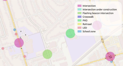
The Transportation Division of the City of Toronto, in partnership with TM3, set a clear goal: to inventory and track all assets located at intersections — including vehicle, pedestrian, and cyclist signal heads, controllers, cameras, pedestrian buttons, poles and arms, flashing beacons, signs, and pavement markings.
🔹 The project began in Scarborough as a proof of concept (POC).
Initially, about thirty asset types were to be surveyed, but after consulting stakeholders, the scope was expanded to 68 distinct asset types to be inventoried per intersection, including crosswalks citywide.
Across a territory with 4,956 intersections and 6,442 km of roads, manual field surveys were no longer viable.
“The idea of walking the entire city with tablets and GPS was simply unthinkable.”
— Terry McSwain, VP Operations, TM3
Following discussions and an agreement with TM3, Jakarto deployed its mobile mapping units for the proof of concept in Scarborough — combining high-density LiDAR (2 million measurements per second) and 4K/360° imaging to create a digital twin of the road network.
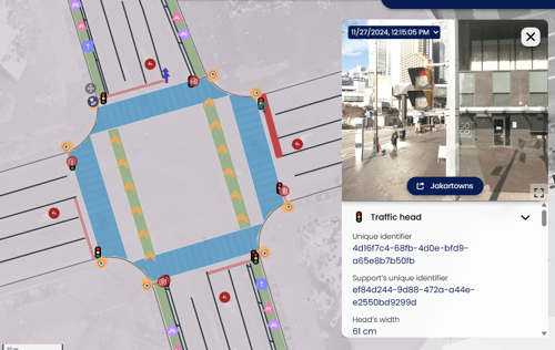
From these datasets, Jakarto demonstrated the efficiency of having a comprehensive, up-to-date inventory at hand to support signal maintenance and improve field operations — with all relevant asset information readily available.
Jakarto was then commissioned to extend the work citywide.
This rich, detailed digital twin now helps optimize numerous aspects of asset and infrastructure management.

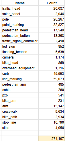
By combining AI and supervised manual extraction, Jakarto identified and classified 274,107 unique assets across Toronto’s 4,956 intersections and 6,442 km of roadway — here’s the complete breakdown!
This hybrid approach allows Jakarto to continuously train its AI models, improving accuracy with each iteration.
All layers and attributes are now accessible in Jakartowns for visualization and within the Esri environment for asset management, enabling direct integration into planning, management, and analysis tools.
🎯 Immediate and Measurable Benefits
⏱️ 50% faster than traditional field surveys (730 days for 6 technicians + one planner/manager), drastically reducing acquisition costs.
🧰 Better-prepared, faster interventions; fewer unnecessary field visits caused by missing information, and increased safety for crews and citizens alike.
🌱 Reduced carbon footprint by cutting non-essential travel.
🤖 Total objectivity: measurements and calculations performed by the machine, according to consistent standards, without human bias for AI-detected assets.
🏙️ A Cross-Department Asset with Multiple Uses
Originally designed to manage traffic signals, Jakarto’s digital twin has limitless potential for other municipal applications:
📏 Virtual surveying: measure distances, surfaces, clearances, and heights directly within the digital twin, reducing field visits by up to 50%.
🌳 Urban forestry: locate and monitor trees, analyze canopy coverage, identify planting sites, and detect potential heat islands.
🚲 Bike lanes & crosswalks: identify safe, connected corridors.
🛠️ Public works: inventory poles, signage, cameras, pavement, and markings while minimizing fieldwork.
🏗️ Urban planning & 3D design: use precise geometry to test redevelopment scenarios.
⚡ Overhead networks & vegetation: detect vegetation encroachments on power or telecom lines.
🚀 Interoperability and the Esri Ecosystem:
From Digital Twin to Smart Mobility with Unlimited Potential**
The true value of a digital twin lies not only in data precision but in its ability to integrate with existing tools and systems.
High-definition LiDAR data and 360° imagery exceeding 70 megapixels, whether captured by Jakarto or third parties, can be processed and transformed by Jakarto to fit seamlessly into the Esri ecosystem — enabling simulation, planning, and optimization of complex urban networks.
Through standardized deliverables — File Geodatabase (.gdb), GeoPackage (.gpkg), WMTS tile services, and LAS/LAZ point clouds — Jakarto’s data can be imported directly into ESRI environment and other GIS/CAD software.
Whether the source is Riegl, Leica Pegasus, or Trimble MX, Jakarto can process and integrate those datasets into its workflow.
🧩 Esri Tools Compatible and Interoperable with Jakarto
Here are some examples of potential integration within Esri’s ecosystem:
🗺️ ArcGIS: analyze intersections, overlay traffic, safety, and active-mobility layers.
🌐 ArcGIS Pro: native LiDAR (LAS/LAZ) handling, 3D analysis, DTM/DSM, and object extraction.
🏙️ ArcGIS Urban: 3D planning scenarios for multimodal corridors and bike networks.
🌆 ArcGIS CityEngine: immersive 3D modeling and “Complete Streets” design.
✅ ArcGIS Survey123: form-based data collection for field teams.
💡 Jakarto provides ground-truth data — high-precision LiDAR + 360° imagery and asset inventories — while Esri’s software suite powers analysis, simulation, and operations: a full data-to-decision continuum for cities.
🌎 Our Mapping Footprint in Canada
Since March 2021, Jakarto has mapped more than 150,000 km of roads across Eastern Canada, now covering nearly 80 % of Quebec’s population.
Our digital twins are available in over 150 cities and municipalities across Eastern Canada — including about 50 in Ontario — showcasing the rapid expansion of our coverage.
This extensive footprint makes Jakarto a key player in geospatial data in Canada, supporting both major urban centers and emerging digital territories with consistent, interoperable, analysis-ready data.
📍 High-quality data + unmatched coverage = accurate, intelligent urban planning.
🤝 Want to Learn More? Contact Us!
Interested in learning more about our projects?
Discover how Jakarto’s digital twins can integrate with your Esri environment or explore potential use cases for your city or organization.
💬 Book a meeting with our team for a personalized demonstration.
📩 Email us at contact@jakarto.com
🌐 Visit www.jakarto.com
Together, let’s bring your data to life and build smarter cities — intersection by intersection.
🔗 Related Articles
-
Urban tree inventory & inspection cycle: the foundation of sustainable urban forest management
-
Public works: faster and more accurate thanks to the digital twin
-
Geomatics: a catalyst for the digital transformation of the territory
COMMENTS