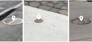
Catch Basins, Manholes & Water Valves
Asset Inventory
The inventory of manholes, catch basins, and water valves is generated from the digital twin, providing a complete and accurate view of your underground infrastructure.
Quickly locate each asset—summer or winter—to support routine maintenance and rapid response in emergency situations.
These data help plan maintenance, improve infrastructure management, and reduce failure risks and operating costs.
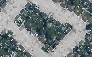
Data Types
Inventory data are delivered as a single set of outputs:
- 2D data: Data file (.shp) containing the geolocation of each asset
- Jakartowns link: Visualize each asset within its geographic context
Trusted by leading organizations