Pavement Markings
Marking Inventory
A complete road marking inventory, ready for your operations and your GIS.
Jakarto automates road marking inventories using the digital twin. You get structured data (point, linear, and polygon) to plan repainting, improve safety, coordinate work, and validate contractor-performed interventions.

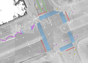
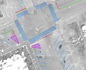
Three Types of Markings
Road markings are delivered in three categories—point, linear, and polygon—each with standardized attributes to support efficient use.
- Point markings (e.g., symbols) and linear markings (e.g., lines) include a unique ID, location, code, description, color, a Jakartowns visualization link, and scan date.
- Polygon markings (e.g., crosswalks, marked zones) include the same attributes and add outline color and fill color to better represent surface areas and their characteristics.


Trusted by leading organizations