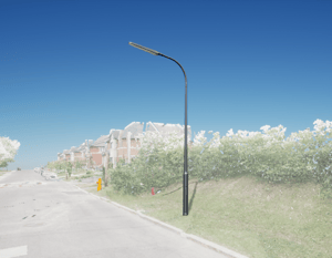
Skip to content
Lampadaire

Street Light Inventory

Street Light Inventory

Street lights are generated from Jakarto's HD LiDAR data already available in the Jakartowns web application. Check out our coverage map.

This inventory data is provided as a single deliverable, which includes a bonus :

  • 2D Data: Data file (.shp) containing the geolocation of each Street light inventory;
  • Jakartowns context URL: For each element, a hyperlink is associated and activatable to open Jakartowns directly at the location in order to visualize the entire geographical context.

Street Light Inventory

Technical details of the inventory

Street Light

  • Street light unique identifier
  • Street light position
  • Hyperlink to view the location in Jakartowns
  • Capture Date

Key information

GEOGRAPHIC COVERAGE

In the event that your geography is not yet in the Jakarto catalog, and according to our geographic coverage planning, the data you desire could be produced as a priority. In the case of a geography outside our planning, they could be produced on request and after evaluation. 

QUALITY AND COMPLETENESS

Although every effort is made to ensure the completeness of the inventory data, it is possible that the inventories may not be 100% complete. If an object obstructs the view of the capture unit, an item behind it cannot be recorded. Therefore, items might be missing in the delivered inventories; we try to limit the proportion of such occurrences.

Lampadaire
lamppost_position

Jakarto in numbers

150 CITIES ALREADY DIGITIZED
100 000+ KILOMETERS DIGITIZED

Do you have a 3D geographic data project?