Data usage
Leverage Jakarto data in several ways
Jakarto data
Jakarto specializes in the creation of what is known as a Digital Twin, which is a faithful 3D representation of the territory covered, whether it is a site, a road or a city. Virtually, one can analyze, inventory and measure assets down to the nearest centimeter.
Jakarto distinguishes itself by maximizing the potential of the digital twin with the help of artificial intelligence (AI). Indeed, AI makes it possible to generate inventories by automating the identification and extraction of landscape elements (e.g. trees), urban infrastructure (street lamps) and roads (traffic signs).
The toolbox for professionals
A single platform bringing together various applications for the exploration and detailed analysis of 3D data.


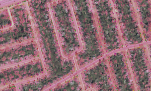
Types of data produced
Jakarto data can be broken down into four main types, depending on whether they are intended to represent the territory or to extract inventory elements, in 2D and/or 3D
![donnees-cartographiques-immersions-3d-jakarto]()
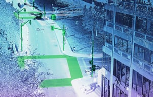
3D Mapping Data
The 3D cartographic data contains a maximum of the detail and precision offered by the sensors used in acquisition. This 3D data can then be used with softwares which support 3D mode, such as GIS (Geographic Information Systems), CAD (Computer Aided Design) and BIM (Building Information Modeling).
![donnees-cartographiques-immersions-2d-jakarto-1]()
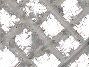
2D Cartographic Data
The 2D cartographic data provides the same high resolution as its original 3D source to support a plan view in CAD. This 2D map data can also be simplified and generalized to allow for smaller scale mapping in a GIS.![GM_Road-DNA_01]()
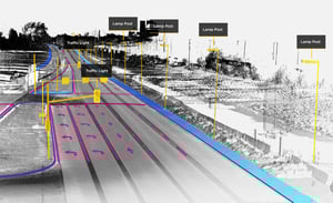
3D Inventory Data
Jakarto's 3D mapping data has the unique characteristic of being "absolute inventory capable", which is essential for the generation of inventory data.Through the power of AI, Jakarto can train and design processing chains specific to each type of inventory. The 3D data is thus analyzed to automatically identify and extract elements from the landscape as well as the urban and road infrastructure. The 3D elements of an inventory theme can be isolated and stored in a database for full exploitation in specialized software and dedicated systems.![Arbre_2D]()
2D Inventory Data
Jakarto can generate an inventory that isolates elements and represents them in 2D. The resulting data goes through a series of treatments with an absolute inventory capacity in order to identify the elements in a 3D universe. However, the extraction simply geolocates them and represents them in 2D, by a geometry in the form of a point, line or zone.

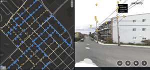
Browse our live coverage map


Jakarto prioritizes the dissemination of data by respecting the standards proposed by the OGC (Open Geospatial Consoritum) or the so-called "de facto standard" formats such as .las for 3D or .shp for 2D.
You have a 3D geographic data acquisition project?
