
❄️ Freeze-thaw: a strategic window for assessing your road network
Every spring, the freeze-thaw cycle puts roads under significant stress. Localized frost heave, surface deformation, gradual settlement, impacts related to watermain breaks, or specific soil conditions: several issues become especially visible when the road network goes through this seasonal transition.
This is exactly when LiDAR surveys deliver their full value.
🎯 Why act now?
Before the thaw season is over, the signs visible on the road network are often at their most revealing. This period makes it possible to document certain phenomena with precision, before they become harder to distinguish later on.
Seasonal deformations do not only reflect the surface condition of a roadway. They can also reveal frost susceptibility issues, structural weaknesses, drainage problems, or impacts related to winter watermain breaks.
For municipalities, this is a concrete opportunity to better understand what is happening on certain streets and corridors, at the right time.
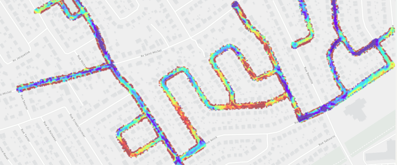
.gif?width=600&height=338&name=Vid%C3%A9o%20sans%20titre%20(4).gif)
🚗 What LiDAR makes visible
By comparing 3D surveys captured during winter with surveys collected in summer, it becomes possible to precisely identify elevation changes in the roadway.
This approach makes it possible to:
- identify the areas where frost heave is most significant;
- compare winter and summer conditions along the same corridor;
- prioritize field inspections;
- better document certain segments before planning repairs;
- support decision-making with measurable, georeferenced data.
So this is not only about observing a problem, but about measuring it, locating it, and targeting interventions more effectively.
📊 From observation to measurement
Traditionally, many freeze-thaw issues are identified through complaints, visual inspections, or targeted field visits. These approaches remain useful, but they do not always make it possible to precisely quantify deformation or gain a consistent understanding of the network.
3D LiDAR surveys add a much more precise layer of analysis. By capturing the true geometry of the roadway at scale, they make it possible to compare surfaces, analyze elevation differences, and objectify the issues being observed.
In other words, this turns field impressions into actionable data.
🏙️ An approach that supports multiple municipal teams
This type of analysis can support several functions within a municipality:
- road maintenance and operations;
- engineering and intervention planning;
- water and sewer networks;
- asset management;
- public works leadership.
The objective is simple: better understand where to act, in what order, and with what level of priority.
🎤 A solution to be presented at TP Québec’s Snow Day
This approach developped with the city of Québec will be presented as part of TP Québec’s Snow Day, where Dave Durand from the City of Québec will give a presentation on identifying frost heave issues using 3D surveys.
It is a strong example of how LiDAR surveys can contribute to a better understanding of infrastructure and to more targeted interventions.
⏱️ A window of opportunity not to miss
If you are observing recurring freeze-thaw issues on certain streets or road segments, this is the right time to act.
This period represents a valuable window to document these phenomena, better target problematic areas, and strengthen your analysis before planning the next round of interventions.
📩 Contact us
Are you dealing with freeze-thaw issues that need to be analyzed?
Now is the ideal time to spot them. Contact us to discuss it.
COMMENTS