HD mapping for mobility
A mapping solution with centimeter-level precision of public roads and infrastructure
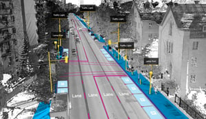
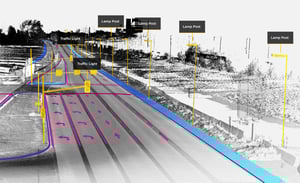
Jakarto's High Volume HD Mapping Solution
Jakarto offers a complete AI-based HD mapping solution: Acquisition, processing, and distribution of LiDAR and imagery data.
At the core of the infrastructure, our cloud-based platform automatically creates a high-definition digital twin of the world as seen from the street.
Further processing allows the classification and extraction of geometric features such as roads, vegetation, road signs, markings, or anything else visible from the street with centimeter-level accuracy.

Why are HD maps necessary for autonomous driving?
Maps found in navigation devices and on our cell phones are mainly for human-use, requiring more or less centimeter-level accuracy, thanks to the power of perception.
We are entering an era where cars will have to make decisions on the road, so we need a new generation of digital maps. Maps specifically designed for robotic systems.
However, to assist the software that will drive the autonomous car, maps need a higher level of accuracy as well as a 3-dimensional view.
Perception system
This system is the digital equivalent of human eyes. It allows the vehicle to see exactly what’s happening on the road. For instance, it’s the system that perceives a pedestrian crossing sign.
Location system
This system tells the vehicle where it’s situated in relation to its surroundings. In other words, it’s the system that lets the vehicle know that it is 2 meters away from the crosswalk.

Planning and control system
This system takes action based on the information provided by the system’s other components. It’s the part of the brain that says: "Okay, I'll slow down and make a full stop at the next intersection."

HD mapping system
This system facilitates the connection between the other three systems. For instance, the HD mapping system works closely and consistently with the location system, deducing what types of objects appear in a certain space. In other words, when a location system reads a specific coordinate, the HD mapping system can quickly match that coordinate with an object. For example, a fire hydrant. Suppose then that the vehicle's perception system sees a moving object passing through. Thanks to the HD mapping system, the vehicle now knows that the object is most likely a pedestrian. The planning and control system then takes the necessary actions to ensure the pedestrian remains safe.

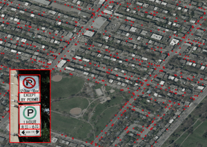
Parking Management
Jakarto collects information on methods and technologies that allows for the collection and maintenance of an accurate inventory of street furniture and regulations.
Street curb data is subjected to a system of validation which verifies the coherence of the signs nearby. They are then transformed in order to adhere to a standard recognized in mobility (CurbLR)
Do you have a 3D geographic data project?
