Skip to content
Point Cloud  LIDAR 2

LiDAR data & imagery

High-definition 3D LiDAR point cloud illustrating the territory.

By default, Jakarto's HD LiDAR data is available in the Jakartowns web application for visualizing the territory, taking measurements, and assisting you in conducting an inventory. Check out our coverage map

Jakarto's HD LiDAR data is also available as raw data so that you can use it in your GIS/CAD/BIM software.

Default file formats: .las and .laz.

Upon request and under certain conditions (fees, timelines, your specifications), Jakarto can generate 3D rasters in .pnts (3D Rasters) format.

Point Cloud  LIDAR 2

Specifications when placing an order:

  • Geographic coverage (a city, a boulevard, a neighborhood, any area specified by you...)
  • File organization (cutting and delivery) according to:
    • Linear, following the road network.
    • Square tiles, an approach to territorial coverage using equivalent tiles.
    • Specific polygons, a personalized territorial coverage approach, by section.
  • Resolution:
    • Full resolution: all captured points.
    • By sampling: point density (resolution) reduced by specifying the most representative point (low, high, average, or central point) for each cell, at a size appropriate to the needs (between 1 cm to 1 m per side, typically 10 cm).


  • Colorization of point clouds by projecting images collected by cameras.
  • Basic classification:
    • Ground
    • Above ground
  • Classification on request (special projects, additional fees):
    • Ground:
      • Road surface
      • Terrain
    • Above ground:
      • Buildings
      • Vegetation
      • Urban furniture
      • Poles and lampposts
      • Signage
      • Other...

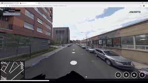
Spherical images (360-degree bubbles) illustrating the territory.

By default, Jakarto's HD spherical imagery is available in the Jakartowns web application for visualizing the territory, taking measurements, and assisting you in conducting an inventory. Check out our coverage map

Jakarto's HD spherical imagery is also available as image files so that you can view and use them in your preferred applications.

Jakarto's HD spherical imagery can also be referred to as or associated with:

  • 360-degree bubble
  • 360-degree panoramic image
  • Equirectangular image
  • Sphere generated from "fisheye" images
File formats: .jpg / .webp + metadata in a structured file

Specifications when placing an order:
  • Geographic coverage (a city, a boulevard, a neighborhood, any area specified by you...)
  • Geographic dimension, in the case of square tiles.
  • Resolution:
    • Full resolution: 8,192 x 4,096 pixels.
    • Resolution reduction according to client specifications/needs.

2_5__How to move on Jakartowns -- tutorials-thumb

Key information

Geographic coverage In the event that your geography is not yet in the Jakarto catalog, and according to our geographic coverage planning, the data you desire could be produced as a priority. In the case of a geography outside our planning, they could be produced on request and after evaluation. 
_03_3d_02_colorisation_3
Point Cloud  LIDAR

Jakarto in numbers

150 cities already digitized
100 000+ kilometers digitized