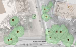
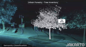
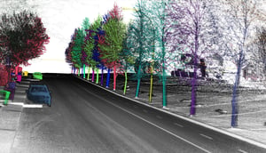
Skip to content
arbre43

Vegetation

These Jakarto data contain the geolocation (X, Y) 
The tree inventory is generated from Jakarto's HD LiDAR data already available in the Jakartowns web application. Check out our coverage map.


Type of Data

This inventory data is provided as a single deliverable, which includes a bonus :

  • 2D Data: Data file (.shp) containing the geolocation of each tree at the center of the trunk;
  • Jakartowns context URL: For each element, a hyperlink is associated and activatable to open Jakartowns directly at the location of the tree in order to visualize the entire geographical context.


Arbre12

Inventory Technical Details

Tree Inventory

  • Tree's unique identifier
  • Tree's position
  • Trunk diameter in meters
  • Trunk diameter standard deviation
  • Trunk diameter measuring method
  • Tree's height in meters
  • Projected crown area in square meters
  • Reference to the unique identifier of the canopy associated with the tree
  • Hyperlink to visualize the location in Jakartowns
  • Capture date

Canopy Inventory

  • Canopy's unique identifier
  • Canopy's projection on the ground
  • Maximum height of the canopy in meters
  • Canopy area in square meters 
  • Hyperlink to view the location in Jakartowns
  • Capture date

Vegetation Analysis

  • Local canopy index
  • Aerial footprint index

Key information

Geographic coverage In the event that your geography is not yet in the Jakarto catalog, and according to our geographic coverage planning, the data you desire could be produced as a priority. In the case of a geography outside our planning, they could be produced on request and after evaluation.
Quality and completeness

Although every effort is made to ensure the completeness of the inventory data, it is possible that the inventories may not be 100% complete. If an object obstructs the view of the capture unit, an item behind it cannot be recorded. Therefore, items might be missing in the delivered inventories; we try to limit the proportion of such occurrences.

Arbre_2D
Arbre46
arbre43

Jakarto in numbers

150 cities already digitized
100 000+ kilometers digitized