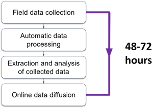
Data processing
Thanks to the digital twin and our AI, the extraction of inventory data is done at more than 200 km/h
Our data handling process
At Jakarto, our expertise goes far beyond the simple acquisition of high-definition geospatial data. We also stand out for our ability to effectively process and integrate data from other capture systems. Thanks to our advanced technologies and mobile mapping units, as well as the ability to utilize third-party data, we are capable of creating accurate and detailed 3D digital twins.
Our process does not stop at data collection. At Jakarto, we employ data processing techniques assisted by artificial intelligence. This approach allows us to transform raw data, whether it comes from our own devices or external sources, into actionable, accessible, and ready-to-use information.
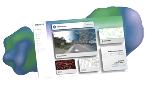
The toolbox for professionals
A single platform bringing together various applications for the exploration and detailed analysis of 3D data.


.png?width=300&height=104&name=Data%20(3).png "Data (3)")
Mastering and using artificial intelligence
Artificial intelligence consists of algorithms that, when well designed and trained, answer their own questions instead of deferring to experts.
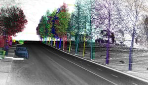
Jakarto uses AI to detect specific objects in its geospatial datasets and map them.
The AI advantage? It saves considerable time and money. The process is automated, and the algorithm runs continually, letting us humans focus on more important tasks.

Do you have a 3D geographic data project?
